Bihar Ki Chauhaddi : Friends, today we will provide you information related to the Chauhaddi of Bihar through our article. Bihar, which is a state located in the north-eastern region of India, is bordered by Nepal. Chauhaddi means the boundary around a place, like the boundary of India, that is, the boundary around India, in the same way we will talk about the states and countries bordering Bihar, so if you are from Bihar and any other country. If you are preparing for the state examination and want to know the Chauhaddi of Bihar’s state Patna, then you must read this article till the end for complete information related to the Chauhaddi of Bihar.

What is the Chauhaddi of Bihar? (What is the Chauhaddi of Bihar?,
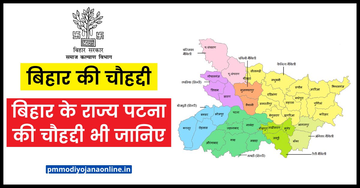
Bihar Ki ChauhaddiThe Chauhaddi of Bihar are as follows – Nepal in the north, West Bengal in the east, Uttar Pradesh in the west and Jharkhand in the south Is. Before the bifurcation of Bihar, Jharkhand also came under Bihar, after which this Jharkhand has become the southern border state of Bihar. Between these two states, there are a total of 8 districts of Bihar, which are bordering Jharkhand, similarly there are districts from the north, east and west states adjoining other states of Bihar, about which we will know in detail, its For remembering the Chauhaddi of Bihar, you can also remember in the name of SEWN-JUWN which is something like this.
See also:- How many districts are there in Bihar, know the number of divisions together
- South in Jharkhand
- East in West Bengal
- Uttar Pradesh in the West
- Nepal in North
Bihar’s Chauhaddi – Bihar Ki Chauhaddi
Bihar Ki Chauhaddi Nepal in the North Nepal is situated in the north of Bihar, out of the boundaries of the four directions of Bihar, only the northern border is the international border which is shared with Nepal. Apart from this, other boundaries are found only with the states of India. Bihar’s international border with Nepal is 601 km long, its geographical location is 26 degree 22 minutes to 30 degree 27 minutes north and 80 degree 4 minutes to 88 degree 12 minutes east.
There are total 7 districts of Bihar from Nepal, in these 7 districts East Champaran, West Champaran, Madhubani, Supaul, Araria, Kishanganj, Sitamarhi is included. The Federal Democratic Republic of Nepal, 85% of its population follows Hinduism. The official language here is Nepali, the capital here is Kathmandu, apart from this Maithili language is used in the areas adjoining Bihar. The total population of Nepal is 28 million, while its GDP is $ 48 billion and per capita income is $ 1500. From the perspective of the Chauhaddi of Bihar, many rivers flow from here towards India.
West Bengal in the East – In the eastern border of Bihar lies the state of West Bengal, which is known as Indian Bengal. The state of Bihar was established in 1912 after the partition of Bengal. The geological location of Bengal to the east of Bihar lies between 85° 50 minutes and 89 degrees and 50 minutes east longitude and 21 degrees and 25 minutes and 27 degrees 13 minutes north latitude. The official languages here are Bengali and English, while Nepali and Hindi are spoken in some parts.
If seen from the eyes of the Chauhaddi of Bihar, West Bengal is in the east of Bihar, whose population according to the 2011 census was 9 crores and the per capita income was about 1 lakh 8 thousand rupees. There are three such districts of Bihar which are bordering West Bengal, in all these districts Kishanganj, Purnia, Katihar This district is included.
Uttar Pradesh in the west In the western border of Bihar lies the border of the state of Uttar Pradesh. Uttar Pradesh is the largest state in terms of population among the states of India, geographically located between Bihar and West Bengal between 25°52′N and 31°28’N latitudes and 77°3’N and 84°39’E longitudes. Which is the fourth largest state in the country on the basis of area. Boundary of 8 districts of Bihar which are separated in the border of Uttar Pradesh in which West Champaran, Gopalganj, Bhojpur, Saran, Kaimur, Buxar, Siwan, Rohtas etc. Districts are included.
Uttar Pradesh which is the largest populous state, its total population is more than about 20 crores, the administrative capital of Uttar Pradesh is Lucknow and the judicial capital is Prayagraj, the state has a total of 75 districts and 18 divisions. Uttarakhand was formed in the year 2000 by bifurcating the hilly regions of Uttar Pradesh.
Jharkhand in the South Jharkhand is located in the southern border of Bihar, after separation from Bihar, Jharkhand was established as a new state, the geographical location of Jharkhand located in the south of Bihar is 21°57’N to 25°14’N latitude and 83°20′ ‘N to 87°58’N. There is an inter-state boundary between these two states, eight districts of Bihar are bordered by Jharkhand, in these districts Aurangabad, Gaya, Banka, Katihar, Rohtas, Nawada, Jamui, Banka, Bhagalpur is included.
The capital of Jharkhand is Ranchi, the entire state is situated on the plateau of Chotanagpur. Jharkhand is counted as one of the most primitive forest region of India, there are tribal settlements in many areas.
how to get bihar land rent receipt online
What is the boundary of Patna, the capital of Bihar? ,Bihar Ki Chauhaddi,
The capital of Bihar is Patna, the old name of Patna was Pataliputra which used to be the capital of India at the time of Ashoka. But one of the specialties of Patna district is that this district is an asa district, whose boundaries meet most of the districts of the country, which are as follows.
East of Patna – Begusarai and Lakhisarai
West of Patna – Bhojpur
North of Patna – Samastipur, Vaishali and Chhapra
South of Patna – Alwar, Jehanabad and Nalanda
Geography and Economy of Bihar
After the partition of Bengal, Bihar was established in the year 1912, hence its name was Bihar. After independence, another partition of Bihar took place in the year 2000, due to which a new state of Jharkhand was formed. Bihar which is a state located in the eastern part of India, its largest city is Patna, whose ancient name is Pataliputra, Kusumpur, Pushppuri, there are 38 districts in Bihar.
It is surrounded by Nepal in the north, West Bengal in the east, Uttar Pradesh in the west and Jharkhand in the south. The Bihar plain is divided into two by the Ganges river which flows from the middle to the east, in its southern part is a fertile alluvial plain irrigated by rivers like the Son, the Gandak and the Kosi.
The main economy of Bihar depends mostly on agriculture, employing about 60% of the agricultural workforce. The state lacks infrastructure and industrial development. For which efforts are being made to promote industrial development through Bihar Industrial Area Development Authority (BIADA).
Several industrial parks have been established by BIADA in the state, including Munger Industrial Park, Begusarai Industrial Park and Bihta Industrial Park. The Gross State Domestic Product (GSDP) of Bihar at current prices for the year 2021-22 is estimated at Rs 7,57,026 crore, an annual growth of 11% over 2019-20, over the previous year 2020 as per Revised Estimates. GSDP is projected to grow by 4.7% in -21.
Questions/Answers related to Chauhaddi of Bihar
What is Bihar Ki Chauhaddi?
Bihar Ki Chauhaddi i.e. those states which are bordering Bihar, are Nepal in the north, West Bengal in the east, Uttar Pradesh in the west and Jharkhand in the south.
What is the total area of Bihar?
The total area of Bihar is 94,163 km square (36,357 sq mi).
Which border of Bihar shares with International?
Bihar has only one border, which is bordered by the international border, that is to the north and Nepal.
What is the Chauhaddi of Bihar’s state Patna?
The boundary of Patna in the state of Bihar, East of Patna – Begusarai and Lakhisarai, West of Patna – Bhojpur, North of Patna – Samastipur, Vaishali and Chhapra, South of Patna – Alwar, Jehanabad and Nalanda
The boundaries of Bihar meet with the boundaries of how many states inside the country?
Bihar meets the boundaries of three states inside the country, in which there is West Bengal to the east, Uttar Pradesh to the west and Jharkhand to the south.
What is the length of the international border of Nepal from Bihar?
The length of the international border from Bihar to Nepal is 601 km.
Which districts of Bihar are adjacent to the international border of Nepal?
of Bihar from the international border of Nepal East Champaran, West Champaran, Madhubani, Supaul, Araria, Kishanganj, Sitamarhi Districts from.
Belonging to the Chauhaddi of Bihar We have provided all the information to you through our article and we hope this information will be very useful for you, for this, if you like our article or have any questions related to the scheme, then you can ask by messaging in the comment box. Huh. We will do our best to answer your questions.
Related Posts –
- सीएनजी पंप डीलरशिप ऑनलाइन आवेदन CNG Pumps Dealership Apply
- विश्व मलेरिया दिवस पर निबंध
- Superset Login Student Registration @joinsuperset.com Hiring 2023
- (पंजीकरण) कृषि इनपुट अनुदान योजना 2023- Krishi Input Anudan Yojana
- फक्त 5 हजारांच्या हप्त्यात येईल 36kmplमायलेजची कार! मेंटेनेन्स दरमहा 400 रुपये
- TN e sevai Login, Status, tnsevai.tn.govt.in